The UW-VIL was deployed in Sheboygan, Wisconsin, for the Lake-Induced
Convection Experiment (Lake-ICE) during December of 1997 and January of
1998. The site (43 44
44 N, 87
N, 87 42
42 W, 176 m ASL) was
located within 10 m of the western shore of Lake Michigan. The VIL's
beam-steering-unit (the point at which lidar beam is transmitted from)
was located approximately 5 m above the lake surface. Thus, horizontal
scans (PPIs) at 0
W, 176 m ASL) was
located within 10 m of the western shore of Lake Michigan. The VIL's
beam-steering-unit (the point at which lidar beam is transmitted from)
was located approximately 5 m above the lake surface. Thus, horizontal
scans (PPIs) at 0 elevation allowed us to map the horizontal
distribution of aerosol and steam-fog in a plane approximately 5 m
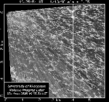
above and parallel to the surface of the lake. Figure 1 is a
PPI scan of this type. Steam-fog and hygroscopic aerosol produced a
high-scattering tracer near the lake surface.
elevation allowed us to map the horizontal
distribution of aerosol and steam-fog in a plane approximately 5 m
above and parallel to the surface of the lake. Figure 1 is a
PPI scan of this type. Steam-fog and hygroscopic aerosol produced a
high-scattering tracer near the lake surface.
 at 5-10 m s
 and
the air temperature was -20
and
the air temperature was -20 C. The open-cells range in
horizontal size from about 100 m at 1 km offshore to about 500 m at
5.9 km offshore.
C. The open-cells range in
horizontal size from about 100 m at 1 km offshore to about 500 m at
5.9 km offshore.
In addition to measuring aerosol scattering on horizontal slices
through the surface layer, the VIL is capable of making vertical slices
(RHIs) through the entire mixed layer and mapping the 3-D structure of
aerosol scattering in the boundary layer. By rapidly moving the laser
beam in a series of RHIs, each with a slightly increased azimuth angle,
we can measure the 3-D structure. For example, a volume scan spanning
40 in azimuth and 15
 in elevation angle
requires about 2 minutes. A typical change in elevation angle between
two laser pulses during an RHI is 0.23
in elevation angle
requires about 2 minutes. A typical change in elevation angle between
two laser pulses during an RHI is 0.23 . By repeating such
volume scans, we can also monitor the temporal evolution of the
structures.
. By repeating such
volume scans, we can also monitor the temporal evolution of the
structures.
Perhaps the most interesting VIL observations during Lake-ICE were
open-cell patterns in the steam-fog about 5 meters above the
surface of the lake on 10 and 13 January 1998. Cold air advection was
occurring on both of these days and visual observations confirmed clear
skies over the lidar site and steam fog on the surface of the lake. On
10 January the minimum temperature reached -16.7 C at 14 UTC
with the wind from 236
C at 14 UTC
with the wind from 236 at 6.5 m s
 . On 13 January the
air temperature dropped to -20
. On 13 January the
air temperature dropped to -20 C and the wind was from
280-290
C and the wind was from
280-290 at 5-10 m s
 . The lake water temperature
on these days ranged from 3 to 5
. The lake water temperature
on these days ranged from 3 to 5 C.
In this paper we focus on the
13 January case, but we intend to present other cases at the poster.
C.
In this paper we focus on the
13 January case, but we intend to present other cases at the poster.
The horizontal cell dimensions increase with increasing offshore distance and appear to be slightly elongated in the direction of the wind. Their somewhat hexagonal shape allows any one cell to share most of its walls with neighboring cells. Cell widths on the left side of figure 1 range from approximately 100 to 500 m while cell widths on the right range from 500 to 1000 m. The streaks across the image are caused by attenuation from the steam fog.
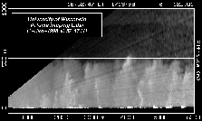
While the steam on the 10th did not appear to rise more than about 50-m above the lake, RHI scans from 13 January, such as figure 2, reveal narrow rising columns of steam which sometimes extend to the top of a 500-m deep mixed-layer. The columns are very bright near the surface and decrease in intensity with altitude. In figure 2, there is one such feature at about 4.4 km range that extends from the surface up to about 200 m. Some of these features may be steam devils and we hope that the VIL observations of them will enable us to quantify their size and number density.